


Key Race Info
| Registrations Open | 8am Saturday 14th February 2026 |
| Early Bird Registrations Close | 11:59pm Sunday 24th May 2026 |
| Registrations Close | 11:59pm Thursday 24 September 2026 |
| Entry Fee | Early Bird – $300 Regular – $335 |
| Race Categories | Male & Female 18-39, 40-49, 50-59, 60+ |
| Start Time |
6:45am Saturday 26 September 2026 The mandatory race briefing will start at 5:55am |
| Cut-off Time |
Overall cutoff of 24hrs 6:45am Sunday 27 September with the below progressive cut offs: First 50k Loop (50K) at 9:15pm Saturday 26 September Second 32k Loop (82k) Course Finish at 6:45am Sunday 27 September |
| Awards Presentation | ~4pm Saturday 26 September 2026 |
| Age Requirements | At least 18 years of age on the event date |
Note: there will be no registrations on the day of the event.
Check out our Race Day Information for all the details.
Entry includes:
 Start and finish precinct Challenging courses Checkpoints and aid stations Professional timing Medical support on course Complimentary race shirt (Early Bird entries only) and buff Volunteer support Gear check Participant guide Finishers medal
Course Summary
Full Course Description
The 50 Miler (82 kilometre) event sees athletes tackling both the 50km loop and the 32km loop in that order. All aid stations and checkpoints noted in both the 50km and 32km courses are relevant and accessible to 50 Miler competitors. 50 Miler runners will all pass through the race village at the 50km mark, in the same manner that the 104km runners do.
The 50km loop starts by heading west from the race village before joining up with some undulating fire roads. After some very runnable fire trail adjacent to Boree Creek, you’ll take a right turn after the Boree Road Aid Station and begin a gentle climb towards Alf Myers Way.
You’ll begin to climb in earnest now and continue to do so, with just a few small descents, until you reach a hard right hand turn, almost switching back on yourself at the 14.5km point. You’ll be met with stunning and endless views to the south towards Cadia as you face a long descent down into established pine forest plantation. After about 6km of steady descending, you’ll begin some short ups and downs until a particularly steep descent before flattening out and running into Rosebank Road Aid Station at 24km.
Having fuelled up here you face around 6km of steady climbing with the mountain summit popping in and out of view as you get back to higher elevations. At the 30km point you’ll be relieved to hit the end of this climb and cruise into the Towac Way Aid Station. Leaving the safety of the aid station sees you take on two technical descents back to back. First up is the epic Glider Trail. Pick your lines carefully and watch your footfalls as you hit the steepest gradient of 32%. After some brief ascents, you’ll then take on the Pine Ridge descent with more downhill gradients over 30%. Keep your eyes on the trail and your ears to the wind, because you’re now within touching distance of the Tea House Aid Station at the 35.5km point.
After such an epic descent, you’re now met with a short ascent on sealed road before flicking right into some wicked downs and up, up, up again as you take on Fern Gully Fire Trail. Another short section of sealed road greets you now but it’s only momentary before you veer left and begin the final push to the summit on the Spring Glade track. The summit sits a full 200 vertical metres above you, and you’ll start to feel the change in temperature and flora as you push ever higher. Before long, you’ll you’ll take a hard right, a few stepped rises, and you’ll pop out of the snow gums and on to the summit itself. Take a breath, ring the bell and grab some nutrition – you’re now standing at the highest point and enjoying the party atmosphere of the Summit Aid Station, with 41km now complete!
From here, you’re about to take on the third epic descent on this loop – Powerline. If you can manage it, take a look at the view and play “spot the race village”, because it’s sitting there somewhere, only 600 vertical metres below you! Bomb the descent and enjoy the adventure of Black Flat Creek trail, knowing that the lower you go, the more you can open your stride. Eventually, you’re down at more reasonable altitudes and running on steadily descending pine needled forest trails, dotted with foliage and flowers. With the creek bubbling beside you to the right, settle into your stride and push over a few final climbs before you swing left and encounter the race village spread out before you. Run past the spectators and to the event site for refuelling on your way to the second loop.
With 50km in your legs, you’re well over half-way but it’s going to take some mental fortitude to head back out onto the mountain. That long descent you just enjoyed from the summit becomes a gruelling ascent. Not only that, the field will get the best indication yet of where they’re sitting in the pecking order as the lead runners will immediately begin seeing the rest of the field descending from the summit as they themselves being to climb again.
Heading west from the race village you’ll exit the event centre before turning left and up a small climb. You will now cross over Mitchells Way and continue on until you eventually turn right onto Black Flat Creek Trail. You will now begin the 600m vertical ascent to the summit of the mountain. Dual tyre tracks interspersed with wildflowers and spring grasses dot much of the climb in the lower elevations.
Your view of the summit is quickly obscured by the ridge lines in the foreground that you inevitably must pass over. After around 6km of steady climbing next to the bubbling creek to your left, your route takes a sharp hairpin to the right and you’re met with a serious incline. This will continue with switchbacks and false flats for the next several kilometres as you climb sharply out of the valleys and begin to see the sprawling farmland below you to the north. You will intersect and turn a sharp left onto Mitchells Way fire trail and, depending on the time of day, you may encounter other runners who are descending to the finish line of the 22km course, or other runners in the 50 Miler event finishing off their 50km loop, at this point.
From here, it’s a serious climb to the top. You will catch the occasional glimpse of the mountain summit off to your right at times, and it’s not long before you can see it all before you as you pop out on to a short section of sealed road before the infamous powerline ascent. This is exposed, wickedly steep and full of breathtaking views. If it’s hot, you’ll feel it here, and if it’s cold, you’re completely exposed on the northern flank of the mountain.
Before you know it, you’ll hit the summit stretch and pop out on to the summit itself at the Summit Aid Station at 59km. You then plunge steeply off the western side and down the Snow Gum track to the Federal Falls crossover and loop. Here you will descend sharply on flowing single track before looping around and climbing, sometimes on technical ground, back towards the Federal Falls Campground. After completing this section, you’ll enjoy 3km of open graded dirt road on the run into the Towac Way Aid Station at 65km. From here, you get breathtaking views to the south as you descend easily for a while, before a hard right hand turn takes you on to the Wombat trail.
Get ready to climb sharply for several kilometres at this point, until you intersect with Gum Ridge trail and begin the long descent towards home. Enjoy the fire trail as it drops you down to the pine forest and then get your single track legs on once more as you take on the flowing Galinbundinya trails towards Boree. At the 77km point, you’ll run through the Boree Aid Station and farewell the single track for the final time.
From here, you face graded dirt roads and occasional fire trails as you set your sights on the race village. You’ll circumnavigate the southern boundary of the farm, before turning left on to Mitchells Way and finishing under the finisher’s arch. Your 50 Miler is now complete.
You went there, and you’re back again… and you’re not going out again!
Map and Terrain
The first loop of the 50 Miler follows the 50k course:


The second loop of the 50 Miler follows the 32k course:
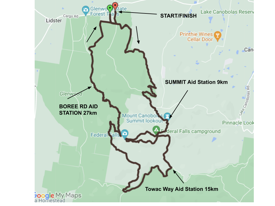

Checkpoints and Aid Stations
|
Location
|
Distance
|
|---|---|
| Boree Road Aid Station | 4k |
| Rosebank Road Aid Station | 24k |
| Towac Way Aid Station | 30k |
| Tea House Aid Station (Support crew & spectators allowed) |
35.5k |
| Summit Aid Station | 41k |
| Race Village (Support crew & spectators allowed) |
50k |
| Summit Aid Station | 59k |
| Towac Way Aid Station | 65k |
| Boree Road Aid Station | 77k |
Provisions will include water, electrolyte drink, hot water for tea, coffee or soup, fruit, lollies, baked goods and crisps. Please note – the exact provisions may vary and we recommend that all participants carry their own nutrition as required, and in line with mandatory gear requirements.
Support crew and spectators are permitted at the Tea House Aid Station and race village only due to the limited road access in other areas. Participants in the 50M and 104K races will pass through the race village during their race and spectators are encouraged to provide support at these points.
Course Flyovers
First loop (50K):

First loop (32K):
